Trail Hikes
Here are a few suggested hikes on our Trail System that you can take, along with some descriptions to give you a sense of their degree of difficulty, length and what each offers. Please contact, Kimberly Benson, the FWC General Manager, to let her know you will be visiting and to determine if she will be at the Niles Cabin at your intended time of arrival. She will be happy to give you an overview of the trails. Hiking our trails is free at all times. However, since we are dependent on donations for supporting our operations, we would appreciate a $10 donation for day use of Rolling Ridge trails when you choose to use the Niles Cabin as your base of operations.
Upper Pond Loop Trail
- Time: 15 minutes
- Distance: ¼ mile
- Difficulty: Easy
- Blaze marks: Yellow plastic tape
- Overview: A meditative meander viewing the front and back sides of the pond. You are likely to see turtles and frogs as well as bluebirds, finches, and chickadees.
- Route directions:
- Start at the rain gauge at the SE corner of Niles Cabin.
- Looking at the pond, walk toward the bench which you will see down the path and to the right.
- Pass the bench and then turn left to cross the berm at the right end of the pond.
- Turn left onto a trail around the backside of the upper pond. Watch carefully for these blaze marks. The trail bends away from the pond to avoid several ant mounds, then returns to the pond.
- Follow the trail to the Niles Cabin to complete the loop.
- Note: This trail is not handicapped- or wheelchair-accessible.
Niles Cabin Loop Trail (NCLT)
- Time: 1 Hour
- Distance: 2 Miles
- Difficulty: Moderate
- Blaze marks: Niles Cabin Trail (orange diamonds), Ridge to River Trail (light blue paint vertical 2×6), Grand Blvd (None)
- Creek fords: 3: Buddha Branch with low to moderate water flow
- Overview: A basic loop to get acquainted with some features of this wilderness.
- Route directions:
- From Niles Cabin cross the berm between the ponds,
- At Orange Diamonds blaze marks turn right then pass the lower pond.
- Turn left then ford Buddha Branch
- Then continue following Niles Cabin Trail
- At its end, turn left onto Ridge to River Trail (toward Ridge) following the light blue painted vertical blaze marks.
- Go through the meadow.
- Turn left onto Grand Blvd (no blaze marks)
- Cross 2 portions of Buddha Branch; in dry times these will also be dry.
- Turn left onto Niles Cabin Trail (Orange Diamonds)
- Soon, watch for the tall free-standing chimney on your left that remains from an 18th Century homestead on this site.
- At end cross the berm, proceed to Niles Cabin.
Niles Cabin to Tree House Trail (NCTT)
- Time: 20 Minutes
- Distance: less than 1 mile
- Difficulty: Moderate
- Blaze marks: Niles Cabin Trail (orange diamonds), Grand Blvd (None), Friends Trail (blue diamonds)
- Creek fords: 1: Krishna Brook (can be heavy flow)
- Route Directions/Overview: Trail from the Niles Cabin to the program area of Fire Circle, Mongolian Yurt, and Tree House. Look for stands of Chestnut Oak and listen for the sounds of Pileated Woodpeckers.
- Route directions:
- From Niles Cabin cross the berm between the ponds.
- Keep going straight onto Niles Cabin Trail (Orange Diamonds).
- Turn left onto Grand Blvd.
- Ford Krishna Brook.
- After a while Niles Cabin Trail ends. Continue on Grand Blvd and Friends Trail.
- Turn right onto Friends Trail (Blue Diamonds)
- Keep going straight, then follow Friends Trail to the right.
- At the parking area on your left, continue following Friends Trail up the hill to the Fire Circle on your left.
- Or, at the parking lot, bear left. Observe dark blue tape and follow the easier alternate trail up to the Mongolian Yurt, Tree House, and Fire Circle
- Note: You can also drive from the Niles Cabin along Friends Way, turn right onto Friends Trail and then proceed to the parking area below the Tree House and Mongolian yurt. We ask that you do not attempt driving all the way to the Tree House.
Ridge to River Trail (RRT)
- Time: 4 Hours
- Distance: 8 Miles
- Difficulty: Moderate – Difficult.
- Elevation change: 900 feet
- Blaze marks: Niles Cabin Trail (orange diamonds), Ridge to River Trail (light blue paint vertical 2×6), Appalachian Trail (white paint vertical 2×6 or white marker)
- Creek fords: 2: at Buddha Branch, Devil’s Racecourse (boulders; hazardous when wet, icy, or snow covered)
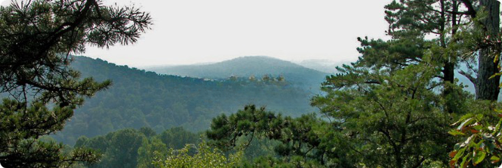
- Overview: From the east on the Blue Ridge toward the west at the Shenandoah River
- Route directions:
- Take Niles Cabin Trail (Orange Diamonds) to its end
- Take Ridge to River Trail (toward Ridge – light blue painted vertical blaze marks).
- Go past junction with Grand Blvd on your left.
- Go past junction with Perimeter Trail on your left
- At Devil’s Racecourse turn right onto Appalachian Trail (white painted vertical blaze marks)
- Turn around at Raven Rocks/Crescent Rocks lookout
- Just past Devil’s Racecourse turn left .
- Proceed along Ridge to River Trail (toward River)
- Go past a sandy spring on your right.
- Go past a second spring on your left.
- Go past junction with Perimeter Trail on your right
- Go past junction with Grand Blvd. On your right
- At Mission Road (not marked), jog north to the orange gate on your left.
- Go under or around the orange gate
- Proceed along Ridge to River Trail (toward River)
- Go past junction with Perimeter Trail on your right
- At the bottom, the trail turns left
- Notice Pawpaw trees, especially in season and if ripe have a bite.
- Notice “Leave Nothing Behind Campsite”
- Notice cairns on your left
- Notice full Waterfalls of Rocky Branch; nice place for refreshment.
- Turn around at Shenandoah River
- Proceed along Ridge to River Trail (toward Ridge)
- Go past junction with Perimeter Trail on your left
- Go under or around the orange gate
- At Mission Road (not marked), jog south
- Proceed along Ridge to River Trail (toward Ridge)
- Take Niles Cabin Trail (Orange Diamonds)
Friends Trail (FT)
- Time: 1 Hour
- Distance: 2 miles (estimated)
- Difficulty: Moderate: some steep, deeply rutted sections
- Blaze marks: Friends Trail (blue diamonds)
- Route Directions/Notes:
- Walk or drive to the Green Gate at Christ Church Road which is .3 mile from the Niles Cabin. Park on the shoulder of Mission Road by Christ Church Road, making sure to leave adequate passing space.
- Most vehicles can drive to the small parking area fairly near the Mongolian yurt, Fire Circle, and Tree House.
- At the left side of this parking area blue tape blaze marks the beginning of an alternate, easier walking path to the Yurt.
- Three tenths mile past the Fire Circle is the spring which is the headwater of Krishna Brook.
- At this spring, take a moment to relax on the bench provided for you.
- Further up Friends Trail is the crossing of Perimeter Trail.
- Yet further up, at Rolling Ridge Foundation property line, blaze marks are not maintained.
- Still further up, is the Appalachian Trail. You will NOT find your way down from the AT if you hike in either direction, as it is not marked; you will need to go south to the Ridge to River Trail, or just turn around and go back on the Friends Trail.
Perimeter Trail (PT) Portion
- Time: 1 Hour
- Distance: 2 miles (estimated)
- Difficulty: Very difficult due to rock flows and downed trees
- Blaze marks: White diamonds
- Creek fords: 2 boulder flows
- Overview: Portion of PT from Friends Trail to Ridge to River Trail.
- Route Directions:
- Take Niles Cabin to Tree House Trail
- Continue on Friends Trail to Perimeter Trail
- Turn right onto Perimeter Trail headed south
- Notice Arrowhead Rock on your left
- Notice Boulders Overlook toward looking west across Shenandoah River; trees obscure/enhance the view
- Observe transition of trail bed to “Jeep trail”.
- Soon trail turns left onto regular trail bed.
- Then trail joins Ridge to River Trail
- Proceed down the hill to the Grand Blvd.
- There, take Niles Cabin Loop Trail either direction to return to start at the Niles Cabin.
Note:
The Perimeter Trail is a loop trail around all the holdings of Rolling Ridge Foundation. Much of Ridge to River Trail carries a portion of this Perimeter Trail. We encourage you to consider hiking all portions of the PT over time. It is a difficult trail but with its own special rewards.
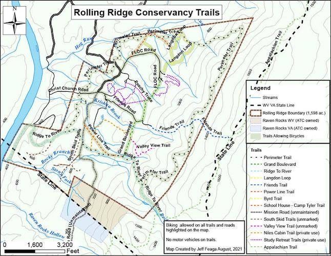
Trail Map
TextHere
TextHere